Chapter 06
Vectoring to Final
Turn an arrival onto the localizer at the right angle and altitude, issue the four-part approach clearance, and hand the flight off to the tower.
Building the pattern on the scope
Chapter 5 brought an arrival off the STAR, stepped it down to a working altitude, and slowed it to a manageable speed. The rest of the approach controller's job is to line that aircraft up with the landing runway, clear it for the instrument approach, and transfer communications to the control tower once it is tracking inbound.
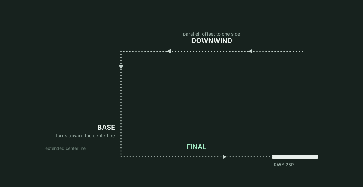
When a pilot flies a visual traffic pattern in clear weather, the path around the airport has three straight legs: a downwind leg flown parallel to the runway and opposite the landing direction, a base leg turned roughly perpendicular toward the extended centreline, and a final leg flown straight down to the threshold. When you issue vectors to the ILS, you build that same three-leg geometry on the radar scope, stretched out over ten to fifteen miles so an instrument arrival can descend and slow down in stages. On radar vectors, you shape the downwind and base legs with heading assignments and then issue a final intercept heading to angle the aircraft across the extended centreline.
An Instrument Landing System (ILS) gives the cockpit two radio beams that replace visual references to the runway. The localizer provides lateral guidance along the extended centreline; on Bayview International's runway 25R, the localizer runs along a magnetic course of 249 degrees on frequency 109.90. The glideslope provides vertical guidance down to the touchdown zone, normally at an angle of three degrees above the horizontal.
While the aircraft is still on the downwind or entering base, you tell the crew which approach to plan for if the ATIS has not already named it or if more than one approach is in use. An "expect" call is advisory information that gives the pilots time to brief the approach chart and tune the localizer frequency. It authorises no turn or descent on its own.
American Two One Five, expect ILS runway two five right approach, turn right heading one six zero, descend and maintain four thousand.
Expect ILS runway two five right approach, right heading one six zero, descend and maintain four thousand, American Two One Five.
The approach gate and the intercept angle
Turning an aircraft from base onto final requires enough distance from the runway and a shallow enough crossing angle for the aircraft to roll out on the localizer without flying through it. Both rules are measured from an imaginary point along the final approach course called the approach gate. The approach gate sits one nautical mile outside the final approach fix, or five nautical miles from the runway threshold, whichever is farther from the airport.
Under standard radar procedures, your intercept heading must bring the aircraft onto the final approach course at least two miles outside the approach gate. That distance gives the pilot or autopilot time to roll out on the localizer and stabilize before reaching the final approach fix. Two exceptions allow a closer turn-on: when the reported ceiling is at least 500 feet above the minimum vectoring altitude and the visibility is at least three miles, you may vector the aircraft to intercept closer than two miles outside the gate, down to the gate itself; and if the pilot specifically requests a shorter turn-on, you may vector the aircraft to intercept inside the gate, provided the intercept happens no closer than the final approach fix. When you work arrivals on opposite base legs (for example, one flight approaching runway 25R from the north and another from the south), you must keep at least 1,000 feet of vertical separation between them until another approved form of separation is established during the turn-on to final.
Except as provided in paragraph 7-4-2, Vectors for Visual Approach, vector arriving aircraft to intercept the final approach course: At least 2 miles outside the approach gate unless one of the following exists: When the reported ceiling is at least 500 feet above the MVA/MIA and the visibility is at least 3 miles (report may be a PIREP if no weather is reported for the airport), aircraft may be vectored to intercept the final approach course closer than 2 miles outside the approach gate but no closer than the approach gate. If specifically requested by the pilot, aircraft may be vectored to intercept the final approach course inside the approach gate but no closer than the final approach fix.
For a precision approach, at an altitude not above the glideslope/glidepath or below the minimum glideslope intercept altitude specified on the approach procedure chart.
The maximum angle at which the aircraft's track may cross the localizer depends on where the intercept occurs. When the aircraft will intercept the course two miles or more outside the approach gate, the maximum intercept angle is 30 degrees. When the intercept point is less than two miles outside the approach gate, or when triple simultaneous approaches are in use, the maximum angle drops to 20 degrees. Helicopters may be vectored to intercept at angles up to 45 degrees.
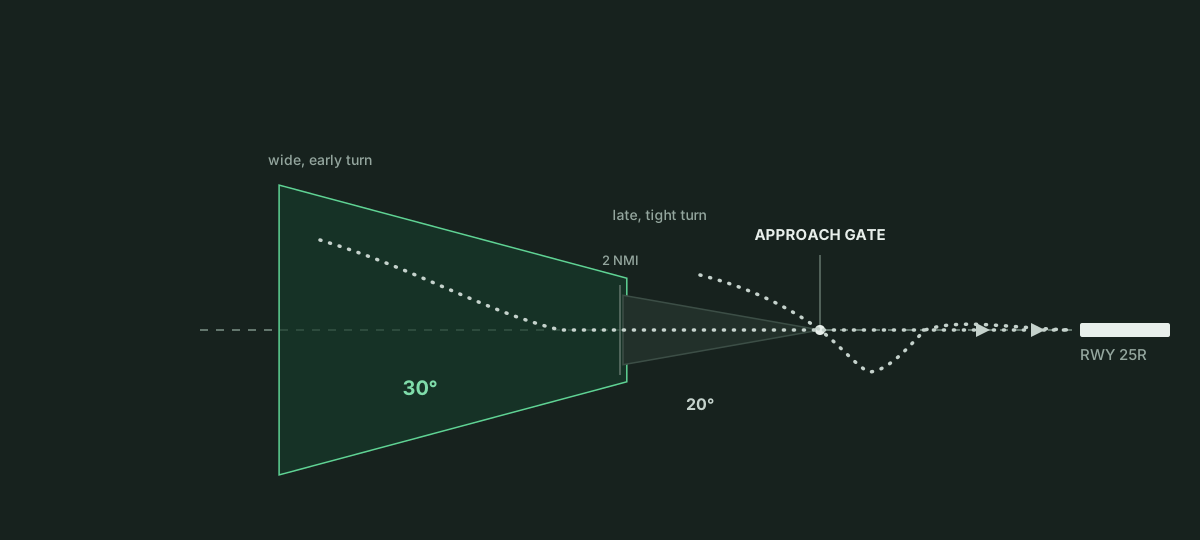
On Bayview's runway 25R (course 249 degrees), a 30-degree intercept from a northern base leg uses heading 220, and a 30-degree intercept from the south uses heading 280. At 180 knots, an airliner covers three miles a minute and needs several seconds to bank into and out of a turn. A turn issued too late on base or at an angle steeper than 30 degrees carries the aircraft through the localizer onto the far side of the course.
Intercepting the glideslope from below
A precision approach requires you to set up the vertical intercept alongside the lateral one. A standard three-degree glideslope rises roughly 300 feet for every nautical mile of distance from the runway threshold: it passes through about 1,500 feet above the touchdown zone at five miles, 2,100 feet at seven miles, and 3,000 feet at ten miles.
You always vector an arrival to intercept the localizer at an altitude below the glideslope so the aircraft flies level into the beam from underneath. While the aircraft tracks inbound in level flight at 3,000 feet, the glideslope needle on the cockpit display starts above the centre mark and moves steadily down as the flight nears the ten-mile point. When the beam meets the aircraft's altitude, the crew or autopilot pitches down into a steady descent of around 700 feet per minute with thrust and airspeed already configured.
An aircraft that reaches the localizer above the glideslope cannot easily recover. Diving from above to catch a descending three-degree path increases airspeed at the moment the crew is extending flaps and landing gear, resulting in an unstabilized approach that normally ends in a go-around. Your vectoring altitude at the turn-on must therefore stay at or above the minimum glideslope intercept altitude on the approach chart (and at or above your sector's minimum vectoring altitude) while remaining below the glideslope at the point where the aircraft crosses the localizer.
The full turn-on clearance
While an aircraft is on radar vectors, it is operating on an unpublished route that has no charted minimum altitudes of its own. FAA rules allow you to clear a vectored aircraft for an instrument approach only after it is established on a segment of a published route or approach, or after you assign an altitude to maintain until it is established.
For aircraft operating on unpublished routes, issue the approach clearance only after the aircraft is: Established on a segment of a published route or instrument approach procedure, or (See FIG 4-8-1)
Assigned an altitude to maintain until the aircraft is established on a segment of a published route or instrument approach procedure. (See FIG 4-8-2.)
An aircraft is established on an approach when it is tracking on the published course (within the capture region of the localizer) and is at or above the minimum altitude published for that segment of the approach. When the arrival reaches the turn-on point on base, you combine four elements into a single transmission in the usual order, remembered by the acronym PTAC:
- Position: distance from a known fix, such as RONBY, so the crew knows where they are on the vector.
- Turn: the final intercept heading within the 30-degree or 20-degree table limit.
- Altitude: the altitude to maintain until established on the localizer.
- Clearance: authorisation to fly the published approach procedure by name.
American Two One Five, seven miles from RONBY, turn right heading two two zero, maintain three thousand until established on the localizer, cleared ILS runway two five right approach.
Right heading two two zero, maintain three thousand until established, cleared ILS runway two five right approach, American Two One Five.
Issuing the approach clearance authorises the pilot to leave the assigned heading once the localizer captures and to leave 3,000 feet once established and on the glideslope. It also cancels any speed assignments you gave earlier; if you still need a specific speed to the final approach fix or the five-mile point, restate it with the clearance. Inside the final approach fix or five miles from the runway, speed adjustment belongs to the pilot. The approach clearance also authorises the published missed approach procedure if the crew has to abandon the approach (covered in chapter 8). If the glideslope is out of service, tell the crew with the clearance by adding "glideslope unusable," or clear the flight for the localizer approach when the chart title allows it.
Monitoring the intercept and handing off to tower
Radar service continues after you issue the clearance; you monitor the target until the flight is transferred to the tower. You can also instruct the crew to "intercept the localizer, report established" when you want a radio call confirming capture. If an aircraft overshoots or deviates from the final approach course after initial interception, your response depends on whether the aircraft is outside or inside the approach gate.
Assign headings that will permit final approach course interception on a track that does not exceed the interception angles specified in TBL 5-9-1.
If deviations from the final approach course are observed after initial course interception, apply the following: Outside the approach gate: apply procedures in accordance with subparagraph a, if necessary, vector the aircraft for another approach. Inside the approach gate: inform the pilot of the aircraft's position and ask intentions.
Phraseology(Ident) (distance) MILE(S) FROM THE AIRPORT, (distance) MILE(S) RIGHT/LEFT OF COURSE, SAY INTENTIONS.
Outside the approach gate, you may assign a new intercept heading within the angle limits if room remains, or cancel the approach clearance, assign a safe altitude and heading, and vector the flight back around for another approach.
United Four Four Seven, cancel approach clearance, turn left heading one six zero, climb and maintain four thousand, vectors for the ILS runway two five right approach.
Cancel approach clearance, left heading one six zero, climb and maintain four thousand, United Four Four Seven.
Inside the approach gate, do not issue new intercept vectors; tell the pilot his distance from the airport and distance left or right of course, and ask his intentions.
An approach clearance can also fail before the intercept if the ILS is out of service, if no ILS exists for that runway, or if surface winds produce a tailwind over ten knots or a crosswind beyond the aircraft's limit. In those cases the pilot refuses the clearance and requests another runway or approach. When weather is well above the minimum vectoring altitude and the crew has the airport or traffic ahead in sight, a visual approach is an alternative that lets the pilot join final by eye.
Once the arrival is established on the localizer, you transfer communications. At an airport without an operating tower, approve a frequency change with "change to advisory frequency approved." At a towered airport like Bayview, instruct the pilot to contact the tower on its frequency near the approach gate or final approach fix.
American Two One Five, intercept the localizer, report established.
Bayview Approach, American Two One Five is established on the localizer runway two five right.
American Two One Five, contact Bayview Tower one one eight point three.
One one eight point three, American Two One Five.
The handoff happens once the aircraft is established on the localizer, since the local controller is not working the radar pattern and the crew needs the tower frequency well before the threshold to receive a landing clearance.
In the Sim
In ATC Simulator, Bayview International's runway 25R uses localizer course 249 on frequency 109.90 with a three-degree glideslope, and the opposite end (runway 07L on course 069) shares 109.90. Runways 33 and 15 use 110.30. Because Bayview publishes no separate final approach fix distance in its data, the approach gate sits at the five-mile floor from each runway threshold. An approach briefing card for each runway lists the localizer frequency and course, the glideslope angle, the approach gate distance, the intercept limits, and the approach, tower, and ATIS frequencies, with mentor explanations available for each item.
You can issue approach calls by voice or through the command controls, which include an expect option, an intercept option, and a handoff control alongside heading and altitude selectors. One voice transmission may combine several instructions and an advisory position call such as "seven miles from RONBY." Clearing a flight with "cleared ILS approach runway two five right" arms the approach and leaves the aircraft on its assigned heading or route until it crosses the localizer between half a mile and thirty miles from the threshold. Assigning "maintain three thousand until established" holds the aircraft at that altitude by suspending published STAR altitude restrictions until localizer capture releases it. Calling "intercept the localizer, report established" is advisory and prompts the pilot to report established on the frequency once captured; pilots refuse it if they have no approach clearance or were cleared to a different runway, and "cancel approach clearance" revokes an active clearance.
The simulation checks both lateral and vertical capture limits. Crossings two miles or more outside the five-mile gate allow up to a 30-degree intercept angle, while crossings closer to or inside the gate allow at most 20 degrees. Exceeding the limit causes the aircraft to fly through the localizer and voids the clearance; the pilot reports "flew through the localizer" with the angle, and you must vector and clear the flight again. Vertically, aircraft capture the glideslope from below in level flight; an aircraft arriving from above captures only if already inside the beam, and any flight more than 600 feet above the slope or more than 30 knots above its final approach speed inside 3.5 miles goes around as an unstable approach.
Pilots refuse an approach clearance if the runway has no ILS, if the ILS is out of service, or if the wind creates a tailwind over ten knots or a crosswind above the aircraft's limit, asking for the opposite runway instead. In visual conditions, "expect visual approach" lets the crew join final visually at angles up to 45 degrees and is refused below visual weather. Handing an established arrival to Bayview Tower on 118.30 scores 25 points (attempts before the flight is established are refused), while an arrival that reaches the threshold without a handoff incurs a 10-point late-handoff penalty. The training ladder covers these steps in lessons 6 ("The ILS"), 7 ("Vectors to final"), and 8 ("The full turn-on").